Wooden boardwalk along dramatic coastal cliffs on the Fisherman’s Trail in Portugal

Fisherman's Trail

14 days long

LEVEL
3
DISTANCE
230 km
DURATION
14 days | 13 nights
PERIOD
Mar Apr May Jun Jul Aug Sep Oct
PRICE FROM
€ 1.068
CO2e FOOTPRINT
210 Kg/person
  1. Portugal
  2.  | 
  3. Self-Guided
  4.  | 
  5. Tourcode PTSW008

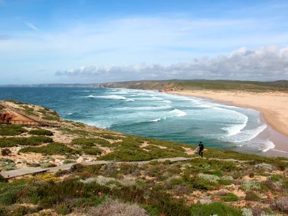
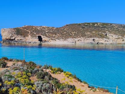
A coastal walking journey through one of Europe’s most unspoilt landscapes. Following the Fisherman’s Trail and sections of the Historic Way, this route takes you from the Alentejo coast into the Algarve, where cliffs meet the ocean, small fishing villages punctuate the shoreline, and Atlantic light shapes every step.

Expect dramatic sea views, quiet rural tracks, golden beaches, whitewashed villages, and evenings spent in carefully selected guesthouses and small hotels. This is a walk of contrasts — wind and sun, cliffs and dunes, sea and countryside — always accompanied by the rhythm of the Atlantic along the Fisherman’s Trail.

Highlights

  • Walk one of Europe’s most scenic coastal paths, tracing cliffs and sandy headlands above the Atlantic.
  • Round dramatic promontories like Cape Sardão and Cape São Vicente, where land meets open ocean.
  • Stay in relaxed fishing and surfing villages such as Vila Nova de Milfontes, Aljezur and Sagres.
  • Swim or pause along wide sandy beaches and hidden coves carved by wind and sea.
  • Discover medieval fortresses, ancient ruins and maritime heritage along the coastline.
  • Optional transfers and balanced stages make this a rewarding yet adaptable coastal journey.

Itinerary

Day 1

Arrival in Vila Nova de Milfontes

Arrival in Vila Nova de Milfontes

Your journey begins in Vila Nova de Milfontes, a charming coastal town set along the banks of the River Mira. After settling into your welcoming Bed & Breakfast in the heart of town, you have time to ease into the rhythm of the Atlantic.

You might take the small ferry across to Praia das Furnas, where wide sandy beaches stretch beneath open skies. Or wander through the old town centre, visit Fort São Clemente overlooking the river mouth, and perhaps pick up some local provisions for tomorrow’s walk. The sea air, the whitewashed houses, the slow pace of the evening — this is your first taste of the Rota Vicentina.

Day 2

From Porto Covo to Vila Nova de Milfontes, 16.5 or 19.5 km

From Porto Covo to Vila Nova de Milfontes, 16.5 or 19.5 km

After a short taxi transfer (included), you reach Porto Covo, where your first stage along the Fishermen’s Trail begins — one of the most scenic sections of the Rota Vicentina.

The path immediately reveals the wild beauty of this coastline. Sandy beaches and wide dune systems accompany your steps, especially around the Ilha do Pessegueiro area. Walking here can be a little demanding, as the trail often crosses soft sand, but the landscapes reward every effort.

The dunes are home to a surprising biodiversity: resilient plants have adapted to the strong Atlantic winds, and you’ll notice pines, rosemary and wildflowers bending almost horizontally under the salty breeze.

If you prefer a slightly shorter day, after about 16.5 km you can arrange a taxi in Canal (not included) to skip the final 3 km of the stage.

Distance: 16,5 or 19.5 km

Elevation gain: +75/-75 m

Day 3

From Vila Nova de Milfontes to Almograve, 12 or 15 km

From Vila Nova de Milfontes to Almograve, 12 or 15 km

In the morning, you cross the estuary by taxi boat (not included) to reach Furnas Beach and rejoin the Fishermen’s Trail. If the boat is not running, you will cross the River Mira via the bridge — on foot or by taxi — enjoying wide views over the inland reed beds.

Today’s walk introduces the ever-changing character of this coastline. Native vegetation mixes with acacia trees brought from afar; stretches of dunes alternate with farmland; traces of old quarries remind you that this landscape has been shaped and reshaped over centuries. It is a day of contrasts, where the Atlantic horizon remains your constant companion.

Distance: 12 or 15 km

Elevation Gain: +75/-75 m

Day 4

From Almograve to Zambujeira 20 or 11 km

From Almograve to Zambujeira 20 or 11 km

This morning a short taxi transfer takes you back to Almograve, where today’s stage begins — around six hours of walking along one of the most striking stretches of the coast. The trail leads you past Cavalheiro and onward to the lighthouse at Cape Sardão, dramatically set above the cliffs. It’s a perfect place to pause for a drink or a simple meal, with the Atlantic stretching endlessly before you.

If you prefer a shorter walk, you can ask the driver to drop you off directly in Cavalheiro, reducing the day’s distance by approximately 9 km.

Distance: 20 or 11 km

Elevation Gain: +175/-90 m

Day 5

From Zambujeira to Odeceixe, 19 km

From Zambujeira to Odeceixe, 19 km

Today you follow the Fishermen's Trail again along the coast- Rolling dunes alternate with rocky shores, where storks nest, and of course another set of beaches:  Alteirinhos, Carvalhal, Machados and Amália.

Treat yourself to lunch at the (fish) restaurant of the natural fishing port of Azenha do Mar, before continuing on to the Seixe River that separates the Alentejo from the Algarve. You stay overnight in a hotel in the upper part of the village of Odeceixe, made up of several typical houses.

Distance: 19 km

Elevation Gain: +220/-230 m

Day 6

From Odeceixe to Aljezur, 19 or 23

From Odeceixe to Aljezur, 19 or 23

From your hotel door, the landscape opens into cultivated fields, heather and fragrant shrubs. The terrain today is gentle and varied, following rural tracks and quiet lanes through the countryside.

In Rogil, a stop at the village bakery is almost obligatory — perhaps the best coffee break of the week. From here, you may choose between the coastal trail leading to Praia da Amoreira (taxi from the beach to Aljezur not included) or a shorter inland route directly to Aljezur.

Your modern hotel in Aljezur offers a small swimming pool and is conveniently located near one of the town’s best restaurants — perfect for a relaxed evening.

Distance: 19 or 23 km

Elevation Gain: +150/-150 m

Day 7

From Aljezur to Arrifana, 17 km

From Aljezur to Arrifana, 17 km


From your hotel in Aljezur, the day begins with a steady climb to the medieval fortress perched at the edge of the plateau, offering wide views over the valley and the Atlantic coast. From here, you cross open land towards the beach of Monte Clérigo, where the landscape shifts once again — cliffs, ocean, and sky blending into one vast horizon.

Turning south, you continue towards Arrifana, a place shaped by centuries of history. Phoenicians, Carthaginians, Romans and Arabs all passed through this coastline. One of its most remarkable features is the site of a former Ribat — an Islamic fortress-monastery founded in the 12th century by Ibn Qasî, a Sufi leader and spiritual guide. It was, as far as we know, the only Ribat in Portugal. Today only evocative ruins remain, set in a spectacular location overlooking the sea.

At Arrifana beach, a taxi will meet you and take you back to your hotel in Aljezur, where you can relax after a day rich in views and stories.

Distance: 17 km

Elevation Gain: +225/-180 m

Day 8

From Arrifana to Carrapateira, 16 or 19 or 23 km

From Arrifana to Carrapateira, 16 or 19 or 23 km

Today’s walk is shaped by the rhythm of the ocean. The Fishermen’s Trail near Carrapateira can only be followed safely at low tide, as certain stretches run along dramatic 100-metre cliffs with no escape route once the water rises. Timing, here, truly matters.

If the tides are not favourable — or if you prefer a different atmosphere — you can follow the inland alternative of the Rota Vicentina, the Caminho Histórico. This route reveals a quieter, unexpectedly beautiful rural landscape, moving between fragrant maquis shrubland, pine forests and open meadows dotted with ancient cork and holm oaks.

Whichever option you choose, the day begins with a short taxi transfer to the fishing village of Arrifana (or, if you prefer a shorter walk, further south to Monte Novo), where you step back onto the trail and continue your journey through this wild and ever-changing coastline.

Distance: 16 or 19 or 23 km

Elevation Gain: +175 or 200 or 325/ - 250 or 265 or 425 m

Day 9

Day of rest or Loop walk Carrapateira, 10 or 22 km

Day of rest or Loop walk Carrapateira, 10 or 22 km

After a full week of hiking, the beautiful surroundings of Carrapateira invite you to enjoy a day of relative rest; on the enormous sandy beach of Bordeira or the surfer's paradise Praia do Amado. Or just enjoying a drink or a meal in the village of Carrapateira where tourists, surfers and fishermen peacefully coexist and enjoy what the sea has to offer in different ways.

If you want to walk, take a short circular walk along two beautiful sandy beaches or extend it to the completely restored village of Pedralva, with café-restaurant and pizzeria.

Distance: 10 or 22 km

Elevation Gain: +125/-215 m

Day 10

From Carrapateira to Vila do Bispo, 16 or 19 km

From Carrapateira to Vila do Bispo, 16 or 19 km

This morning you continue south, following the Fishermen’s Trail as it winds along the cliffs and occasionally dips into the gently rolling inland. The Atlantic remains your constant companion — sometimes far below, sometimes almost within reach — while the path alternates between sandy stretches, rocky outcrops and open views that seem to stretch endlessly.

In the early hours, you may come across local fishermen perched on narrow rocks jutting out over the sea, perfectly balanced as they cast their lines into the deep blue below. It’s a striking image, one that captures the raw, authentic spirit of this coastline.

Gradually, as you move inland, the white houses of Vila do Bispo appear on the horizon. The historic town signals the end of today’s stage — a welcoming place to rest, wander its quiet streets and reflect on another day shaped by wind, ocean and wide-open landscapes.

Distance: 16 or 19 m

Elevation Gain: +400/-350 m

Day 11

From Vila do Bispo to Sagres, 20 km

From Vila do Bispo to Sagres, 20 km

Today’s stage is one of the most spectacular of the entire journey. You round the south-westernmost tip of mainland Europe, walking across stark limestone cliffs sculpted by wind and sea. The landscape feels raw and elemental here — wide skies, crashing waves, and a sense of standing at the very edge of the continent.

At Cape São Vicente, pause to visit the old fortress and lighthouse, dramatically positioned above the Atlantic. It’s a place long associated with explorers, pilgrims and sailors — a symbolic threshold between land and open ocean.

From here, the trail turns east, following the coastline toward Sagres. The fortress of Sagres comes into view as you approach this laid-back seaside town. You’ll stay here for two nights, close to the beach and near the marina of Baleeira — the perfect setting to unwind after such a memorable day on the cliffs.

Distance: 20 km 

Elevation Gain: +120/-200 m

Day 12

From Sagres to Salema, 16 or 20 km

From Sagres to Salema, 16 or 20 km

The stretch between Sagres and Salema is considered one of the most demanding stages of the Fishermen’s Trail. The path rises and falls continuously along rugged cliffs, following stony footpaths that require steady footing and a good rhythm. It is a physically engaging day — but also one of the most rewarding.

Here, the Algarve reveals its most dramatic side. Wind and ocean have sculpted the limestone into striking rock formations, creating a coastline of hidden coves, carved cliffs and vast Atlantic views. Every ascent is repaid with wide panoramas; every descent leads toward another beautiful beach. Along the way, you’ll pass Martinhal, Barranco, Ingrina, Zavial, Furnas, Figueira and finally Salema — each offering the possibility of a refreshing swim if the conditions allow.

The area also carries traces of its layered past: Roman pottery workshops once stood on these plains, and near Ponte de Fisga you can still see the remains of an 18th-century fortress overlooking the sea.

If 20 km feels too ambitious for the day, you can arrange for a taxi pick-up in Figueira (after approximately 16 km) instead of continuing to Salema. In the afternoon, you’ll return to your hotel in Sagres, where a well-earned rest awaits.

Distance: 16 or 20 km

Elevation Gain: +260 or 345/- 230 or 370 m

Day 13

From Salema to Lagos, 17 or 23 km

From Salema to Lagos, 17 or 23 km

This morning a taxi brings you back to Salema — or slightly further east to Burgau — where you begin the final stage of your journey along the Fishermen’s Trail.

The coastline here is among the most iconic in southern Portugal. As you walk eastward, golden cliffs rise above turquoise waters, and the Atlantic has carved extraordinary shapes into the rock. Near Ponta da Piedade and Praia do Camilo, you’ll pass some of the Algarve’s most famous sea caves, arches and hidden grottoes — a landscape shaped slowly and powerfully by wind and waves.

This stretch of coast has long been strategic: Romans, Arabs and later the Portuguese built forts here to defend the shoreline from pirates and invaders. Their traces still punctuate the horizon, reminders that these paths have always been routes of passage.

Your journey concludes in the historic town of Lagos, set along the banks of the Bensafrim River. It’s a lively yet atmospheric place to celebrate the end of your walk — perhaps with a final dinner overlooking the marina, as the sun sets over the Atlantic.

Distance: 17 or 23 km

Elevation Gain: +330/-530 m

Day 14

Arrivederci Portugal!

Arrivederci Portugal!

After breakfast your arrangement ends.
 

Details

Included


Qué está incluido

  • 13 noches en habitación doble en hoteles, B&B y agriturismos con desayuno
  • Transporte de equipaje de hotel a hotel los días 3, 5, 6, 8, 10, 11 y 13
  • Traslados según el programa, los días 2, 3, 4, 7, 8, 12 y 13
  • Mapas y descripción detallada del itinerario
  • Asistencia telefónica 24h

Qué no está incluido

  • Traslados al punto de inicio y desde el punto de llegada del tour
  • Almuerzos y cenas, salvo que se indique lo contrario
  • Visitas y entradas a monumentos, museos o parques – propinas
  • Gastos personales
  • Posibles tasas de estancia
  • Todo lo que no se mencione en la sección “Qué está incluido”

Servicios opcionales

Estos servicios pueden añadirse al precio base del tour:

  • Suplemento por habitación individual
  • Suplemento para viajeros solos
  • Seguro de cancelación
  • Noches adicionales en cualquiera de los alojamientos estándar a lo largo del recorrido
  • Envío de documentos impresos al primer alojamiento
  • Traslado opcional al final de la ruta en el día 6
  • Traslados en taxi opcionales para acortar caminatas los días 4, 8, 12 y 13

Classic Hotels


For our trips, we always choose accommodation with private rooms and private bathrooms. In rare cases, shared accommodations or shared bathrooms may be provided, so we recommend carefully checking the inclusions section to understand the type of accommodation included in the trip you are interested in.  

We place great importance on the choice of accommodations and select hotels with care and attention. We understand how essential it is to rest well after a day of walking. We always prefer cozy and characteristic establishments, preferably family-run, that fully embody the spirit of the place and offer hospitality with courtesy and comfort.  

Where, due to the nature of the route, accommodation options are limited, we choose the one that best aligns with our standards.

When to travel


You can start this journey on any day of the week, subject to availability, between April and December.

Spring and early summer offer mild temperatures, blooming landscapes and long daylight hours — ideal conditions for walking along the Atlantic coast. Autumn is also a wonderful season, with softer light and fewer visitors, though some hotels may close for annual holidays. In these cases, alternative accommodations can be arranged, occasionally with a small supplement.

During the height of summer — particularly from late June to late August — temperatures can be very high. While the sea is always close and beaches offer refreshing breaks, shade along the trail is limited. On warmer days, it’s essential to start early, carry sufficient water and food, and walk at a comfortable pace.

Choosing the right season depends on your tolerance for heat and your preferred atmosphere — livelier in summer, quieter and cooler in spring and autumn.

Is this for me?


The Rota Vicentina is a dramatic and rewarding coastal walk, designed for those who love wild landscapes and the constant presence of the Atlantic.

This trip is right for you if:

  • you are comfortable with medium-length walking days (around 18–25 km);
  • you don’t mind sandy sections and uneven cliffside paths;
  • you enjoy open horizons, ocean winds and the strong southern Portuguese light;
  • you are looking for a nature-focused experience where the landscape takes centre stage;
  • you like balancing walking days with time to relax by the sea.

It may not be ideal if you prefer fully shaded trails or consistently even terrain. Along the coast, shade is limited and the sun can be strong, especially in summer. A reasonable level of fitness and comfort walking on sand and exposed sections is important.

In return, the Rota Vicentina offers one of Europe’s most authentic coastal walking experiences: golden cliffs, fishing villages, solitary lighthouses and sunsets that seem to stretch endlessly.

If you love the sea, here you will truly walk alongside it — step by step.

What to bring


Clothing and other items
You will need your regular walking/cycling gear, including some sort of reflective garment. For the evenings, smart outdoor style trousers (or shorts) are invaluable, as are quick-dry t-shirts. These can be washed easily and will dry overnight and still look good for sightseeing or having a drink in town.

Take as little as possible to avoid potentially lugging a heavy suitcase up three flights of stairs at the end of the day. Please be aware that laundromats (“Laverie”) are not common in rural areas, so plan to do handwashing of small items.

Lightweight walking shoes/ trainers
For wearing around towns & villages. They can also be a back-up pair.

Socks & underwear
Take only good quality socks with quick-dry and insulating qualities. Road test them before you go on the trip. Take a suitable quantity of underwear as washing facilities are limited.

Warm jacket, hat, gloves
Bring a fleece, Polartec or warm layers for the evenings especially in spring or autumn; be sure it is totally suitable for your needs.
A fleece jacket which blocks the wind (Wind-stopper) is the most preferable. In the summer months a lightweight jacket is suitable for evenings.
If you are cycling/walking in mountainous or coastal areas, even in the height of summer, the weather can change very quickly and unexpectedly and you should be prepared for fog, mist, rain, snow or hail at any time. Always take an extra layer with you, as well as a warm hat and gloves.

Waterproof jacket & trousers
If you are caught in heavy rain, with good waterproof clothing you should remain dry. Remember that most garments will lose their properties over time. Few will remain waterproof for more than five years and many deteriorate in three years or less. We recommend a rain jacket with a good hood and collar and waterproof or thermal walking/cycling trousers or tights.

Dress code
In general, you should wear suitable clothing when entering a church (in many places, it is considered unacceptable to go inside wearing shorts or a tank-top). We suggest that women carry a shawl to cover up bear shoulders or low-cut tops. It also comes in handy when your shoulders get sunburned!

It is considered inappropriate for men to go without a shirt / T-shirt (other than at the beach).

Trekking poles (adjustable)
Highly recommended. A pair works best, depending on what you are comfortable with. If you suffer from back or knee pain this should be considered essential. Remember to practise walking with your pole(s) on different types of terrain in the months preceding your trip.

Walking boots
The importance of good footwear cannot be stressed enough. Your boots should be sturdy and of good enough quality to handle all types of terrain. Lightweight boots, (cordura/leather boots) which have Gore-Tex or sympatex water-proofing are most suitable for this trip. They should provide good ankle protection and be well broken in. Waxing leather boots regularly prolongs their life.

Walking tops & trousers
We recommend walking trousers and shorts and quick-dry wicking t-shirts. These can be washed easily and will dry overnight and still look good for sightseeing or having a drink in town. Wicking T-shirts are fast drying, keep moisture away from your skin and are available at outdoor stores. You should also bring one pair of loose-fitting trousers to wear in cities and for evenings out, etc. Shorts or zip-off trousers are useful in warmer weather.

Practical info

How to arrive


Nearest airports to fly to are Lisbon airport (LIS) and Faro airport (FAO).
 
Arrival in Vila Nova de Milfontes

From Lisbon airport: Take a bus from Lisbon airport to Sete Rios bus station in Lisbon city centre. Then take bus from Lisbon-Sete Rios bus station to Vila Nova de Milfonte. There are several busses per day and the average travel time is 3 hours and 40 minutes in total.

Departure from Lagos

To Lisbon airport: From Lagos you can travel directly to Lisbon in almost 4 hrs by public transport 

To Faro airport: you first can travel by bus with Vamus to Faro  in approximatley 2 hours

If you prefer to travel by train from lagos to Faro that is possible, but you have to walk a bit to reach the shuttle bus to the airport; crossing the pedestrian bridge, then alonside the harbour

Then you continue by bus or taxi to Faro Airport.


Mobile App


GUIBO is the app that allows you to easily follow your daily walking routes, with maps, tracks and useful information always available on your smartphone.

Practical information
With the download you will have access to three main sections:

  • Tour itinerary: The complete map of your trip with day-by-day routes.
  • Things to know: Useful information such as emergency numbers, travel programme, accommodations and points of interest.
  • Service: Technical support, FAQs and assistance if needed.

What to bring with you
To use the app at its best, we recommend having:

  • a fully charged smartphone or tablet (iPhone, iPad or Android)
  • the GUIBO travel app installed
  • the credentials to unlock your trip
  • a fully charged power bank

You may also like:


Wanderlust Nominee Best Specialist Tour Operator 2025
Wanderlust
Nominee Best Specialist Tour Operator 2023
SloWays
Change currency:

We accept:

VISA MASTERCARD

We accept:

VISA
MASTERCARD
FTO ATTA member
RePower Travelife
ISO Partner ISO Partner
FTO ATTA member RePower Travelife ISO Partner ISO Partner

Touroperating
S-Cape Countryside Travels srl
Borgo Allegri 16R
50122 Firenze FI
P. IVA 05227330486

 
© 2026 SloWays. All rights reserved.
Touroperating S-Cape Countryside Travels srl Borgo Allegri 16R 50122 Firenze FI, Italy
VAT Nr 05227330486
extraSmallDevice
smallDevice
mediumDevice
largeDevice
largeDevice
largeDevice