Splendid panoramic view of the the Dolorama Trail

Dolorama Trail, a View on Dolomites

Level
2
Distance
60 km
Duration
durationtype 7 days | 6 nights
period
Jun Jul Aug Sep
price from
€ 820
CO2 footprint
87 Kg/person
  1. Italy
  2.  | 
  3. Self-Guided
  4.  | 
  5. Tourcode ITSW450

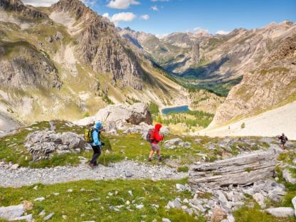
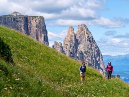
A walk in the magical atmosphere of the Dolomites, a land of wild open spaces, green meadows and jagged peaks standing out against the deep blue sky: from the beginning to the end you walk surrounded by glaciers, ridges and massifs, enjoying spellbinding views that make every walk unforgettable.  
The Dolorama walks are quite easy, even if some of them are longer, making this trip suitable for almost everybody, and one of the easiest multi-day hikes in the Dolomites area.  
A must-do for first timers and families, surrounded by the most beautiful peaks of the world. The Dolorama trail consists almost entirely of forestry paths and hiking trails and is only crossed once by a paved road. Along the way there are many rest areas and observation points to stop at: for example, the prehistoric settlement site at Astmoos on the Luson/Lüsner Alm pasture or the geological site on the Würzjoch ridge, which shows traces of hundreds of million years of Earth's history. 

Highlights

  • Ever changing, always amazing sceneries of the Dolomites  
  • Warm, comfortable family-run accommodation
  • Rich flora and fauna, and tasty mushrooms!
  • Friendly locals with a unique cultural heritage
  • Superb culinary, including delicious cheeses, carne salada, polenta, mushrooms, speck and outstanding wines 

Itinerary

Day 1

Arrive in Bressanone

Arrive in Bressanone
Arrive with public transport or private transfer to Bressanone, easily reachable by train, check-in at the accommodation and enjoy the peaceful atmosphere of this quiet mountain town. Bressanone is a colorful, lively city and the oldest of the whole Tyrol: if you arrive early, take the chance to stroll through its colorful alleys and visit the frescoed rooms of the bishops’ palace.

Day 2

Transfer to Zumis and walk to Rifugio Kreuzwiese, 9 km

Transfer to Zumis and walk to Rifugio Kreuzwiese, 9 km
This morning you are transferred to Zumis, where the route starts (30min). The first stage of Dolorama is a very gentle yet steady incline, traversing the sprawling landscape of the Rodenecker-Lüsner Alm mountain pasture. It provides hikers with insights into life in the South Tyrolean Alps, and is surrounded by impressive panoramic views of the Pfunderer Mountains and panoramic walks with great views of the Alpine chain at the border between Austria and Italy. It runs mostly on gravel tracks. You pass through farms dominated by the typical mountain pastures.

Distance: 9 km

Elevation gain: +332 / -145m

Day 3

From Rifugio Kreuzwiese to Rifugio Montemuro, 11 km

From Rifugio Kreuzwiese to Rifugio Montemuro, 11 km
Right at the beginning of the second stage of the route, hikers experience the unique UNESCO World Heritage Site of the Dolomites. Hiking through the enormous geological rock outcrop at Würzjoch ridge, hikers will witness hundreds of millions of years of geological history. It's a relatively easy walk with great views of the Alpine chain at the border between Austria and Italia and the northern Dolomites. You walk mostly on a ridge from where you dominate Brunico's valleys. A short detour at the beginning of the trail allows to reach a spectacular viewpoint.

Distance: 11 km

Elevation gain: +638 / -435 m

Day 4

From Rifugio Montemuro to Rifugio Genova, 14 km

From Rifugio Montemuro to Rifugio Genova, 14 km
The third stage of the route is accompanied by the typical birdcall of the nutcracker, winding through sparse pine forests. It's a slightly demanding walk which runs along mountain footpaths and gravel tracks. Approaching the Rifugio Genova you have spectacular views of the Sass Putia and from the views are majestic, you can dominate the entire Val Badia with its valleys and massifs

Distance: 14 km

Elevation gain: +748 / -561 m

Day 5

From Rifugio Genova to Rifugio Resciesa, 16 km

From Rifugio Genova to Rifugio Resciesa, 16 km
It's a slightly demanding walk which runs along mountain footpaths and gravel tracks. The first part skirts the Odle Massif with breathtaking views of its cliffs. The view dominates the Val Gardena and Alpe di Siusi (with views of Sasso Lungo Massif). Towards the end you can descend to the funicular station to reach Ortisei.

Distance: 16 km

Elevation gain: +696 / -836 m

Day 6

From Rifugio Resciesa to Laion, 10 km

From Rifugio Resciesa to Laion, 10 km
It's a very easy walk which runs along gravel tracks and footpaths mostly through the forests. You gradually descend from Rifugio Resciesa to Laion enjoying views of Isarco River valley and its mountains. Nestled in the middle of the South Tyrol, surrounded by the loveliest mountains in the world, Laion is situated on a high terrace embedded between vineyards and alpine pastures.

Distance: 10 km

Elevation gain: +42 / -1105 m

Day 7

Arrivederci Dolomiti!

Arrivederci Dolomiti!
Your arrangement ends here, unless you have booked a transfer or an extra night with us.

Details

Is this for me?


This journey is excellent for approaching the Dolomites without venturing into too challenging paths: you will enjoy beautiful views and the beauty of the Dolomites without having to embark on technical hikes. Even ascents and descents are much more manageable than other mountain routes: it is, however, a route that requires good training because it involves walking between mountain huts and, therefore, does not include rest days.

Included


What is included

  • 6 Nights in double room in **/*** hotels , B&B and huts with breakfast (more information in the Accommodation section), possibilty of shared bathroom 
  • 4 picnic lunches
  • Transfer from Bressanone to Zumis (day 2)
  • maps and detailed description of the itinerary in digital form, app
  • Medical and luggage travel insurance
  • 24h phone assistance

What is not included 

  • Transfers to the starting location and from the arriving location of the tour
  • lunches and dinners, if not otherwise stated
  • visits and entrance fees - tips
  • personal expense
  • possible sojourn taxes
  • everything that is not mentioned in the "What is included" section.

Optional Services

These services can be added to the ones included in the base price of the tour:

  • Single room supplement
  • cancellation insurance
  • Transfers to reach the starting location or to leave the arriving location of the tour, which will be quoted on request.
  • travel documentation in printed form (maps and detailed description of the itinerary), shipped to the first hotel

Accommodation


We work with 3* hotels, B&Bs and farmhouses that reflect our way of experiencing travel: they are comfortable and characterful structures, which we choose one by one, managed by passionate and welcoming people.

Unless otherwise specified in the travel listing, all provide private en-suite rooms with breakfast included.

Below you see some examples of the facilities used for this trip, but keep in mind that they may vary based on availability in the period. We could therefore book for you structures different from those you see listed here, but of the same category and carefully chosen according to SloWays criteria.

Residence Gasser - Bressanone
Rifugio Kreuzwieser Alm - Lusen
Rifugio Monte Muro - San Martino in Badia
Rifugio Genova - Funes
Rifugio Resciesa - Ortisei
Albergo Al Sole - Laion

When to travel


In Trentino Alto Adige you will experience the typical mountain weather. In June you will still find patches of snow here and there. Like in all mountainous areas, the weather can be unpredictable and can change quickly so always check the weather forecast before setting and always take with you a rain jacket, warm hat and gloves.

What to bring


Clothing and other items
You will need your regular walking/cycling gear, including some sort of reflective garment. For the evenings, smart outdoor style trousers (or shorts) are invaluable, as are quick-dry t-shirts. These can be washed easily and will dry overnight and still look good for sightseeing or having a drink in town.

Take as little as possible to avoid potentially lugging a heavy suitcase up three flights of stairs at the end of the day. Please be aware that laundromats (“Laverie”) are not common in rural areas, so plan to do handwashing of small items.

Lightweight walking shoes/ trainers
For wearing around towns & villages. They can also be a back-up pair.

Socks & underwear
Take only good quality socks with quick-dry and insulating qualities. Road test them before you go on the trip. Take a suitable quantity of underwear as washing facilities are limited.

Warm jacket, hat, gloves
Bring a fleece, Polartec or warm layers for the evenings especially in spring or autumn; be sure it is totally suitable for your needs.
A fleece jacket which blocks the wind (Wind-stopper) is the most preferable. In the summer months a lightweight jacket is suitable for evenings.
If you are cycling/walking in mountainous or coastal areas, even in the height of summer, the weather can change very quickly and unexpectedly and you should be prepared for fog, mist, rain, snow or hail at any time. Always take an extra layer with you, as well as a warm hat and gloves.

Waterproof jacket & trousers
If you are caught in heavy rain, with good waterproof clothing you should remain dry. Remember that most garments will lose their properties over time. Few will remain waterproof for more than five years and many deteriorate in three years or less. We recommend a rain jacket with a good hood and collar and waterproof or thermal walking/cycling trousers or tights.

Dress code
In general, you should wear suitable clothing when entering a church (in many places, it is considered unacceptable to go inside wearing shorts or a tank-top). We suggest that women carry a shawl to cover up bear shoulders or low-cut tops. It also comes in handy when your shoulders get sunburned!

It is considered inappropriate for men to go without a shirt / T-shirt (other than at the beach).

Trekking poles (adjustable)
Highly recommended. A pair works best, depending on what you are comfortable with. If you suffer from back or knee pain this should be considered essential. Remember to practise walking with your pole(s) on different types of terrain in the months preceding your trip.

Walking boots
The importance of good footwear cannot be stressed enough. Your boots should be sturdy and of good enough quality to handle all types of terrain. Lightweight boots, (cordura/leather boots) which have Gore-Tex or sympatex water-proofing are most suitable for this trip. They should provide good ankle protection and be well broken in. Waxing leather boots regularly prolongs their life.

Walking tops & trousers
We recommend walking trousers and shorts and quick-dry wicking t-shirts. These can be washed easily and will dry overnight and still look good for sightseeing or having a drink in town. Wicking T-shirts are fast drying, keep moisture away from your skin and are available at outdoor stores. You should also bring one pair of loose-fitting trousers to wear in cities and for evenings out, etc. Shorts or zip-off trousers are useful in warmer weather.

Practical info

Mobile App


Use the SloWays APP for iOS and Android smart phones in combination with the written documentation provided.

The App has the detailed tracks and maps that you can use offline and without roaming. Thanks to the phone’s internal GPS, you can check your exact position on the map, so you always know exactly where you are. It also helps you self-navigate you way while travelling. More information on how to use the App inside the roadbook documents.

The navigation features include:

  • Offline navigation. Mobile data not required after initial download
  • Accurate GPS tracks
  • Autorotation of the maps
  • Daily route summary and elevation chart
  • Panorama of the track and at street level
  • Alarm and vibration that alerts you in case you go off track.
  • Emergency SMS button with position coordinates
  • Possibility to record and take georeferenced photos of problems on route alerting fellow travelers
  • Hotel information
  • Points of interest along the way
  • Historical background

Wanderlust Nominee Best Specialist Tour Operator 2023
Wanderlust
Nominee Best Specialist Tour Operator 2023
Change currency:

We accept:

VISA MASTERCARD

We accept:

VISA
MASTERCARD
FTO ATTA member
100% Green Travelife
FTO ATTA member 100% Green Travelife

Touroperating
S-Cape Countryside Travels srl
Borgo Allegri 16R
50122 Firenze FI
P. IVA 05227330486

 
© 2024 SloWays. All rights reserved.
Touroperating S-Cape Countryside Travels srl Borgo Allegri 16R 50122 Firenze FI, Italy
VAT Nr 05227330486

We and selected third parties use cookies or similar technologies for technical purposes and, with your consent, for functionality and marketing (personalised ads) as specified in the cookie policy. Denying consent may make related features unavailable.

With respect to advertising, we and selected third parties, may use precise geolocation data, and identification through device scanning in order to store and/or access information on a device and process personal data like your usage data for the following advertising purposespersonalised ads and content, ad and content measurement, audience insights and product development.

You can freely give, deny, or withdraw your consent at any time by accessing the preferences panel.


Use the “Accept” button to consent. Use the “Reject” button or close this notice to continue without accepting.

extraSmallDevice
smallDevice
mediumDevice
largeDevice
largeDevice
largeDevice