The landscape of Val di Merse among the Etruscan way
 The landscape of Val di Merse among the Etruscan way

Etruscan Way, Volterra to Buonconvento

Level
1
Distance
97 km
Duration
8 days | 7 nights
period
Mar Apr May Jun Jul Aug Sep Oct Nov
price from
€ 0
CO2 footprint
135 Kg/person
  1. Italy
  2.  | 
  3. Self-Guided
  4.  | 
  5. Tourcode ITSW550

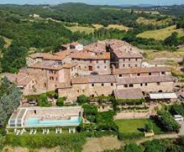
This journey is dedicated to one of the most enigmatic and fascinating peoples in history – the Etruscans. Even though part of their history is shrouded in mystery, their traces in the Tuscan territory are many, precious, and clearly visible: they can be found, in particular, between Val di Merse, Val d'Elsa, and Val d'Orcia, where votive statues and cypress keys, tombs, and ancient roads are hidden.

The path itself is marvelous – you'll walk among olive groves, vineyards, and fig trees, ancient Roman roads and Etruscan sunken roads, in the lunar landscape of the Val d'Orcia hills, tinted with enchanting shades. What more could you ask for? Perhaps wine – but fortunately, this is a blessed land in this sense, and the food is even better.

Highlights

  • Visit the natural, artistic and cultural treasures of the Etruscan population
  • Wonderful landscapes, wide open fields, cypress lined hills and vineyards
  • Incredibly well preserved medieval and renaissance villages and hilltop towns
  • Peaceful country roads, friendly Tuscans and delicious regional culinary specialties

Itinerary

Day 1

Arrive in Volterra

Arrive in Volterra
Arrive in the ancient Etruscan city of Volterra, after check in take your time wondering through town where you can explore its Alabaster artisan shops, the interesting Etruscan Museum and the Roman Theatre, superb palaces and alluring city walls. Veláthri (the Etruscan name for Volterra), was part of the Etruscan confederation, known as the Etruscan dodecapolis, and from the second half of the 6th century BC enlarged the walls defending the acropolis to a circumference of about 1,800 metres, in practice the plane below the summit of the hill; this process was completed in the early 5th century BC.

Day 2

From Volterra to Mazzolla, 10 km

From Volterra to Mazzolla, 10 km
Today you start your holiday through history, passing through the extraordinary territory surrounding Volterra where the Tuscan countryside is at its wildest. The route ends at the small village of Mazzolla from where you have a breath-taking view of the iconic Tuscan landscape.

Distance: 10 km

Elevation gain: +290/-500 m

Day 3

From Mazzolla to Casole d'Elsa, 18 km

From Mazzolla to Casole d'Elsa, 18 km
The day’s walk goes along paths and country roads. For a long stretch you walk through the “Tatti Forest”, one of the most important in Italy for the presence of the Oak (Quercus petraea), which is not very common in the Mediterranean environment.

Distance: 18 km

Elevation gain: +460/-335 m

Day 4

Morning transfer from Casole d'Elsa and walk to Sovicille, 20 km

Morning transfer from Casole d'Elsa and walk to Sovicille, 20 km
A short transfer in the morning will take you to the start of the walk near Casa Verniano. From here you start a long walk through the area known as the “Montagnola Senese”. You walk mostly through the forests along main and secondary roads. Along the way you will pass by the Etruscan Tumulus of Mucellena, one of the most significant archaeological sites in Tuscany. Along the way are two striking Romanesque parish churches.

Distance: 20 km

Elevation gain: +688/-614 m

Day 5

From Sovicille to San Rocco a Pilli, 11 km

From Sovicille to San Rocco a Pilli, 11 km
The day’s walk is short and easy across the tuscan plain separating the two villages. Along the route you can stop and visit the Etruscan Necropolis of Malignano. The earliest evidence of man in this area is very ancient, but at the rise of the Etruscan civilisation, the last centuries of the Iron Age, in the period from the 8th century B.C. to the 7th century B.C., a princely tomb was excavated in the necropolis of Malignano, very articulated and twenty metres deep. Around this, in the Archaic period, most of the other chamber tombs were added, which in this necropolis have a certain variety of types.

Distance: 11 km

Elevation gain: +109/-130 m

Day 6

From San Rocco a Pilli to Vescovado, 19 km

From San Rocco a Pilli to Vescovado, 19 km
It is a long walk along the hills bordering the Val d'Arbia valley. You pass through the iconic Tuscan landscape of round shapes, vast fields, farmhouses and small villages. The enormous and renowned fertility of the fields, the presence of a large waterway such as the Arbia, and the ever-increasing importance assumed by the 'Strada Francigena', soon created the conditions for villages of a certain density to develop on the plains as well.

Distance: 19 km

Elevation gain: +471/-436 m

Day 7

From Vescovado to Buonconvento, 19 km

From Vescovado to Buonconvento, 19 km
On the last walk you wonder though a wild area which follows the narrow valley of Crevole stream. You pass through Murlo (a charming medieval village with a very important Etruscan museum which we recommend a visit) and Miniera di Murlo where the ancient mines and factories where based. Then you walk through the iconic hills of Val d’Orcia towards Buonconvento where you can celebrate the end of your holiday through history sipping a glass of the famous Montalcino red wine.

Distance: 19 km

Elevation gain: +600/-740 m

Day 8

Arrivederci Buonconvento!

Arrivederci Buonconvento!
Our services end after breakfast, unless you have booked another service with us.

Details

Is this for me?


This journey is perfect for those who love ancient history or simply want to immerse themselves in the iconic Tuscan countryside.

It's a trip suitable for those with some training or who have undertaken walking trips in the past - most days cover about 20 km, and Tuscany with its hilly landscape might put a bit of strain on less trained legs.

Included


What is included

  • 7 Nights in double room in **/*** hotels , B&B and agriturismi with breakfast
  • luggage transportation from hotel to hotel (max 1 item per person)
  • transfer from Casole d'Elsa to Casa Verniano
  • maps and detailed description of the itinerary in digital form, app
  • Medical and luggage travel insurance
  • 24h phone assistance

What is not included 

  • Transfers to the starting location and from the arriving location of the tour
  • lunches and dinners, if not otherwise stated
  • visits and entrance fees - tips
  • personal expense
  • possible sojourn taxes
  • everything that is not mentioned in the "What is included" section.

Optional Services

These services can be added to the ones included in the base price of the tour:

  • Single room supplement
  • cancellation insurance
  • Transfers to reach the starting location or to leave the arriving location of the tour, which will be quoted on request.
  • travel documentation in printed form (maps and detailed description of the itinerary), shipped to the first hotel

Accommodation


We work with 3* hotels, B&Bs and farmhouses that reflect our way of experiencing travel: they are comfortable and characterful structures, which we choose one by one, managed by passionate and welcoming people.

Unless otherwise specified in the travel listing, all provide private en-suite rooms with breakfast included.

Below you see some examples of the facilities used for this trip, but keep in mind that they may vary based on availability in the period. We could therefore book for you structures different from those you see listed here, but of the same category and carefully chosen according to SloWays criteria.

Albergo Etruria - Volterra
B&B La Pecora Nera - Mazzolla
Hotel Terre di Casole - Casole d'Elsa
Casale Il Colombaio di Toiano - Sovicille
Villa Fattoria di Cavaglioni - San Rocco a Pillii
Bike Resort Bosco della Spina - Murlo
Hotel Roma - Buonconvento

When to travel


The  climate  in Tuscany  is  generally  very mild  with  differences  depending  on  the geography  of the  region,  from  coasts  and valleys to the continental areas.The warmest months are generally July and August,  with  temperatures  ranging  from 23°C up to 30°C; the valleys can often see higher  temperatures  and  38°C  to  40°  C  is not uncommon. While  June  and  September  offer  both  nice warm weather. Of course, there are always exceptions  or  dry  spells  that  cause  a  few days to get really hot.Spring    (April    and    May)    and    Autumn (October   and   November)   are   dry, with sunny  days  but  the  chances  of  rain  are high. The  weather  can  change  very  quickly  and you must be prepared forrain, mist, wind, fog   (and   even   hail   or   snow   at   higher elevations) –especially   in   spring and autumn. 

What to bring


Clothing and other items
You will need your regular walking/cycling gear, including some sort of reflective garment. For the evenings, smart outdoor style trousers (or shorts) are invaluable, as are quick-dry t-shirts. These can be washed easily and will dry overnight and still look good for sightseeing or having a drink in town.

Take as little as possible to avoid potentially lugging a heavy suitcase up three flights of stairs at the end of the day. Please be aware that laundromats (“Laverie”) are not common in rural areas, so plan to do handwashing of small items.

Lightweight walking shoes/ trainers
For wearing around towns & villages. They can also be a back-up pair.

Socks & underwear
Take only good quality socks with quick-dry and insulating qualities. Road test them before you go on the trip. Take a suitable quantity of underwear as washing facilities are limited.

Warm jacket, hat, gloves
Bring a fleece, Polartec or warm layers for the evenings especially in spring or autumn; be sure it is totally suitable for your needs.
A fleece jacket which blocks the wind (Wind-stopper) is the most preferable. In the summer months a lightweight jacket is suitable for evenings.
If you are cycling/walking in mountainous or coastal areas, even in the height of summer, the weather can change very quickly and unexpectedly and you should be prepared for fog, mist, rain, snow or hail at any time. Always take an extra layer with you, as well as a warm hat and gloves.

Waterproof jacket & trousers
If you are caught in heavy rain, with good waterproof clothing you should remain dry. Remember that most garments will lose their properties over time. Few will remain waterproof for more than five years and many deteriorate in three years or less. We recommend a rain jacket with a good hood and collar and waterproof or thermal walking/cycling trousers or tights.

Dress code
In general, you should wear suitable clothing when entering a church (in many places, it is considered unacceptable to go inside wearing shorts or a tank-top). We suggest that women carry a shawl to cover up bear shoulders or low-cut tops. It also comes in handy when your shoulders get sunburned!

It is considered inappropriate for men to go without a shirt / T-shirt (other than at the beach).

Trekking poles (adjustable)
Highly recommended. A pair works best, depending on what you are comfortable with. If you suffer from back or knee pain this should be considered essential. Remember to practise walking with your pole(s) on different types of terrain in the months preceding your trip.

Walking boots
The importance of good footwear cannot be stressed enough. Your boots should be sturdy and of good enough quality to handle all types of terrain. Lightweight boots, (cordura/leather boots) which have Gore-Tex or sympatex water-proofing are most suitable for this trip. They should provide good ankle protection and be well broken in. Waxing leather boots regularly prolongs their life.

Walking tops & trousers
We recommend walking trousers and shorts and quick-dry wicking t-shirts. These can be washed easily and will dry overnight and still look good for sightseeing or having a drink in town. Wicking T-shirts are fast drying, keep moisture away from your skin and are available at outdoor stores. You should also bring one pair of loose-fitting trousers to wear in cities and for evenings out, etc. Shorts or zip-off trousers are useful in warmer weather.

Practical info

Mobile App


Use the SloWays APP for iOS and Android smart phones in combination with the written documentation provided.

The App has the detailed tracks and maps that you can use offline and without roaming. Thanks to the phone’s internal GPS, you can check your exact position on the map, so you always know exactly where you are. It also helps you self-navigate you way while travelling. More information on how to use the App inside the roadbook documents.

The navigation features include:

  • Offline navigation. Mobile data not required after initial download
  • Accurate GPS tracks
  • Autorotation of the maps
  • Daily route summary and elevation chart
  • Panorama of the track and at street level
  • Alarm and vibration that alerts you in case you go off track.
  • Emergency SMS button with position coordinates
  • Possibility to record and take georeferenced photos of problems on route alerting fellow travelers
  • Hotel information
  • Points of interest along the way
  • Historical background

Wanderlust Nominee Best Specialist Tour Operator 2023
Wanderlust
Nominee Best Specialist Tour Operator 2023
Change currency:

We accept:

VISA MASTERCARD

We accept:

VISA
MASTERCARD
FTO ATTA member
100% Green Travelife
FTO ATTA member 100% Green Travelife

Touroperating
S-Cape Countryside Travels srl
Borgo Allegri 16R
50122 Firenze FI
P. IVA 05227330486

 
© 2024 SloWays. All rights reserved.
Touroperating S-Cape Countryside Travels srl Borgo Allegri 16R 50122 Firenze FI, Italy
VAT Nr 05227330486

We and selected third parties use cookies or similar technologies for technical purposes and, with your consent, for functionality and marketing (personalised ads) as specified in the cookie policy. Denying consent may make related features unavailable.

With respect to advertising, we and selected third parties, may use precise geolocation data, and identification through device scanning in order to store and/or access information on a device and process personal data like your usage data for the following advertising purposespersonalised ads and content, ad and content measurement, audience insights and product development.

You can freely give, deny, or withdraw your consent at any time by accessing the preferences panel.


Use the “Accept” button to consent. Use the “Reject” button or close this notice to continue without accepting.

extraSmallDevice
smallDevice
mediumDevice
largeDevice
largeDevice
largeDevice